
Here you can find and compare the widest variety of quality sporting equipment. For family and hobby sports or intensive, personal workout and endurance sports. Plus the proper clothing and accessories to get just what you need at a price that fits your budget.
Sports gear and apparel for all sizes, all sports and all seasons. This shop has equipment for every sports activity. You'll find the right gear to enjoy your favorite sports. Find your specialized sports apparel and accessories here too. Better than just finding what you want. Here you can compare prices, brands and stores and get the best price for your favorite brand.
Sports gear and apparel for all sizes, all sports and all seasons. This shop has equipment for every sports activity. You'll find the right gear to enjoy your favorite sports. Find your specialized sports apparel and accessories here too. Better than just finding what you want. Here you can compare prices, brands and stores and get the best price for your favorite brand.
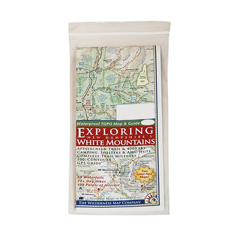
Exploring Nh's White Mountains Map
With this detailed, easy-to-read map in your pack, you'll be able to enjoy more than 70 day hikes, 50 waterfalls, and 100 points of interest throughout the beautiful White Mountains of New Hampshire. Double-sided map shows The “White Mountain Trail” Region on one side and the Presidential Range – Wild River on the other. White Mountain Trail Region side:~ Details everything between Franconia and Conway~ Scale: 1:100,000 (1 in. = 1.6 mi. = 2.5 km)~ Includes hiking/trip planning tips and the “Hiker Responsibility Code”. Presidential Range – Wild River side:~ Scale: 1:62,500 (1 in. = 1 mi. = 1.6 km)~ Includes hiking safety tips. Includes picnic areas, viewpoints, AMC huts, camping areas and shelters, covered bridges, trout fishing areas, shuttle stops, and more. Features 100 ft. contours, complete trail mileages, and GPS grids. Printed on coated paper. 9 x 4 in. folded / 24 x 18 in. unfolded / Exploring Nh's White Mountains Map
Extra 20% Off on Clearance at EMS!
Price:
$0.00 from
Sold by
Product Name
Price